
A Galloway Glens Historic Landscape

Gaelic place names and evidence of historic land use in Kells parish on Southern Uplands Way.
I was hoping to present this in person as a contribution to the Galloway Glens Landscape Character Assessment on Friday 10 February 2017. Unfortunately the day long event was upstairs in Castle Douglas Community Centre and I had my son Callum with me in his wheelchair. The Community Centre has a stair lift but not a lift lift so I will post what I was going to discuss here instead.
I hope the notes and copies of documents/ maps are straightforward, but if not I will reply to any comments left.
This is information about the series of events on the Galloway Glens website.
The Galloway Glens Scheme will be supporting a suite of projects in the landscape of the Ken/Dee Valley, from Carsphairn in the north to Kirkcudbright in the south. Over the next few months, Northlight Heritage and a team of specialists in landscape studies will be working closely with communities in the area to better understand the local landscape and what makes it unique.
The team plan to take a holistic approach, integrating geology, bio-diversity, archaeology, history, folklore and many other strands, to create a fuller understanding of the overall picture of the landscape. This process, known as Landscape Character Assessment, is customary in all Landscape Partnerships that have been supported by the Heritage Lottery Fund, currently numbering around 100 across the UK.
The Landscape Character Assessment includes two main elements. A formal data gathering exercise has already begun, which will bring together information from a range of national and local organisations such as Dumfries and Galloway Council, Scottish Natural Heritage and Historic Environment Scotland. This process is designed to build a picture of the natural and cultural assets of the area which are protected or designated, such as Listed Buildings.
Alongside the more formal elements, the team will also be out and about as part of the Sights & Sites community engagement programme. They are keen to find out which places and views are important to local people, through a series of informal drop-in workshops and events across the area. ‘Landscape’ is interpreted in its broadest sense – not just as traditional views and scenery but as how people relate to it, changes to it in the past, present and future, and family connections to the area. The report will be freely published and available to all and promises to be a genuinely interesting review of the local landscape.
http://www.gallowayglens.org/what-do-you-think-makes-the-landscape-special/
The landscape I am interested in is not going to be part of the ‘formal data gathering exercise’ because there are no ‘protected or designated’ sites within it. However, it is also likely to be missed out within the ‘informal’ part of the process because the historical sources of information about the landscape are not well known.
For example, the medieval Exchequer Rolls of Scotland and the Kirkcudbright Sheriff Court Deeds 1623-1700 are specialist/ academic historic sources which are not very easy to understand and interpret. I only made the connections between these sources, the landscape and its Gaelic place names while researching the Galloway Levellers uprising of 1724.
The Galloway Levellers opposed the eviction of people from farms to create ‘cattle parks‘ for herds of cattle which were then driven south to be sold in England. I needed to know how cattle farming in Galloway operated before the export trade with England developed. Going through the two volumes and 6000+ entries in the Kirkcudbright Sheriff Court Deeds 1623-1700 I found a two tacks (leases) for a farm which described how cattle were pastured on the 2000+ feet high Rhinns of Kells ‘in the summer half of the year’.
The Scottish Gaelic word ‘airigh’ means summer pasture. In the same (southern) part of the Rhinns of Kells there are two ‘airigh’ farms, both which had belonged to the medieval Lords of Galloway. My argument is that this suggests a continuity of land use over about 700 years which can-uniquely- be backed up by documentary evidence.
I scanned and printed supporting documents and maps ready to take along to the drop-in session. Here they are:
Airigh is a Gaelic word for land used as summer pasture. There are several ‘airigh’ farms in the Galloway Glens once of which was recorded as ‘Clonnaree’ (now Clenrie) in 1456. This comes from ‘claon airigh’ meaning sloping summer pasture. Clenrie is on the east side of Miekle Millyea on the Rhinns of Kells and on the Southern Upland Way.
In 1678 and 1686, tacks (leases) for Drumbuie which is adjacent to Clenrie were drawn up. Both these tacks require the tenants to return any cattle pastured during the summer on Straveron Hill (on the west side of Meikle Millyea) to return them to the ‘heft’. This evidence suggests a continuity of land use, where the Rhinns of Kells were being used as summer pasture of approximately 700 years. Drumbuie was also recorded in 1456 as one of the farms which had belonged to the medieval Lordship of Galloway.
To the south of Clenrie and Drumbuie is Mid-Garrary which was recorded in 1456. This is another airigh farm name, from ‘garbh airigh’, rough summer pasture. Between Clkenrie and Mid-Garrary is Eldrick Hill. This is from the Gaelic ‘eileirig’, a deer trap.
In this part of the Galloway Glens we can see how the Gall-Ghàidheil, the Gaelic speaking descendents of Vikings, were able to make use of the resources of the Galloway uplands 1000 years ago. The pattern of land use established by the Gall-Ghàidheil s until the end of the eighteenth century when large sheep farming became the dominant land use. Since the 1960s, sheep-farming in turn has given way to forestry as the dominant land use, although this particular area has fortunately not been planted.
An extra layer of historical interest is contained in a tack for Hannaston and Drumbuie from 1741. The tenants were Samuel McConnel and his son John. In 1779, John McConnel’s brother James was the tenant of Hannaston. As noted in the Old Statistical Account for Kells, the lands had been improved by John Newall of Barskeoch and the rent was doubled. James McConnel was unable to pay the new rent and left the farm in 1782.
The year before, his son James had decided not to become a tenant farmer and moved to Lancashire where his uncle William Cannan manufactured spinning mules and textile machinery. William’s father Thomas had been a tenant in Drumbuie. After serving his apprenticeship, James moved to Manchester.
Here, in partnership with John Kennedy from Knocknalling, also in Kells, James McConnel established a cotton spinning business which by 1815 had become the largest in Manchester.
Sources
After the surrender of Threave castle in the summer of 1455 to James II, the king requested William, Abbot of Dundrennan, to compile a list of all the lands in Galloway which had been owned by William, 9th earl of Douglas, as Lord of Galloway. The list of what were now Crown lands was produced in 1456 and recorded in the Exchequer Rolls of Scotland.
[1. Map and list, from Andrew McCulloch Galloway-a Land Apart Edinburgh, 2000. ]
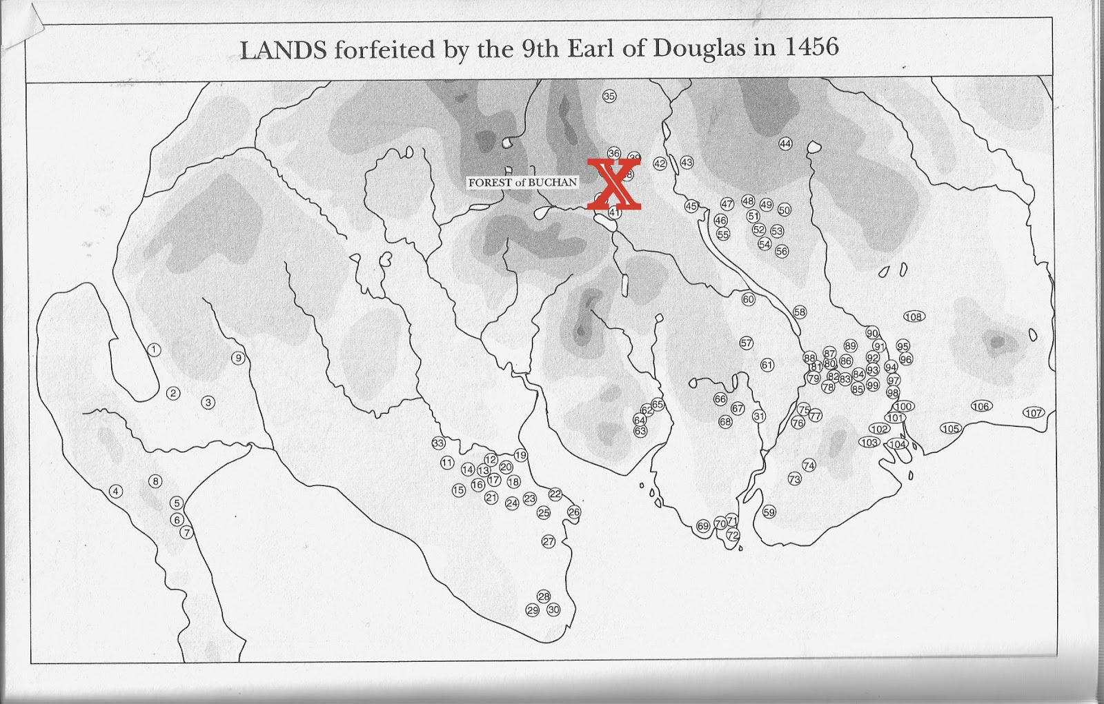

These lands included a cluster in Kells parish along the Garroch Glen from the river Ken to the Rhinns of Kells- Barskeoch (Barnskeach), Largvey, Largmore (Largmor) Drumbuie (Drumboy) and Clenrie (Clunnaree).
[2. Exchequer Rolls, Edinburgh, 1882, p.192]

Through the sixteenth century, most of the Crown lands in Galloway were sold off. The Gordon family acquired the lands in Kells but by the mid-seventeenth century the Newall family were owners of Barskeoch, Drumbuie, Clenrie, etc. Two later seventeen century tacks (leases) for Drumbuie exist.
[3. Kirkcudbright Sheriff Court Deeds 1675-1700, entries 1052 and 1420]
Kirkcudbright Sheriff Court Deeds 1675-1700 (Edinburgh, 1950)
Entry 1052 TACK (15 July 1686) by Adam Newal of Barskeoch, heritable proprietor of the lands under-written, to William and Andrew McClamrochs, lawful Sons to John McClamroch of Craginbay, of the 4 merkland of Drumbuy, with the pertinents, presently possessed by William Calwel and Andrew Irland, for 9 years from Whitsunday 1679, (with the option to both parties of ending this Tack after 5 years) for the payment of £120, the usual teind, prebendar and feu duties, public burdens, work and casualties for the first year, and after Whitsunday 1680 they are to pay 200 merks yearly with the foresaid duties, 2 stone of good butter or 10 merks, 1 dozen poultry fowls and 2 "fasterinevine henns;" and " to pay and lay in the work and service" of 40 loads of peats, providing sacks for carrying them, and 2 barrows with bearers to peat casting, 4 "naigs" one day yearly to harrowing, 2 men and 2 horses one day to the hay-stack making, and 4 shearers yearly, paying £3 in satisfaction of other work and service of men and horses paid by the present possessors ; the said Adam is to give timber, great and small, for the upkeep of the houses which the said William and Andrew are to keep wind and water tight;
should any of the said Adam’s cattle pasturing in Staiverran the summer half year come home through the said "rowme," the tenants promise not to molest them but either to put them back to the "heft" or allow them to pass peaceably homeward ; they are to pay all public burdens, maintenance taxations and levies of foot or horse and will be allowed the half of all discharges for such which they produce. At Clauchen of Dalry 2 December 1678 witnesses Robert Greirsone of Mylmark, John McNaght in Overtoune, James Chalmer of Wattersyd, and William Hunter in Midtowne of Clauchen.
Entry 1420 TACK (2 December 1689) by Adam Newall of Barskeoch, heritable proprietor of the lands under-written, to James McCutchine, lawful son to the deceased Alexander McCutchine in Drumbuy, of the half of the 4 merkland of Drumbuy and the piece called the Lumpe between the burns, with the pertinents, presently possessed by the said James, for five years from Whitsunday 1686, for the yearly payment of 160 merks, 1 stone of good salt butter in the summer time or 5 merks as the price thereof, 6 poultry fowls, and a fasteneven hen, with the work of 25 loads of peats, providing good sacks to carry them, with a man and a horse, a man and a spade and 2 bearers a day to the casting of them, a man and a horse to hay-stacking, "with a man and sheirs to the cliping off Straveran," and a man and a horse to fetch a load of lime or free stone; the said Adam promises to give timber, great and small, for upholding the houses and the said James is to keep them wind and water tight and leave them in good condition, and he is to leave " ryll trees and soil trees and staiks and doors and the lyk" which Andrew McClemeroch, present
tenant, leaves in the houses ; should any of the said Adam’s cattle pasturing in Strauveran the summer and harvest half year come to the Braidside or through his ground, the said James promises to put them back to the "heff" again; he is to pay all public burdens and be allowed for the same in his rent. At the Watersid 26 May 1686 ; witnesses Thomas Macaw in Garroch, Robert Macaw, his son, John Paisla, schoolmaster in Barskeoch. and John Makill there.
A tack from 1741 for Hannaston and part of Drumbuie also exists.
[4. Facts and Traditions Collected for a Family Record, David McConnel, Edinburgh, 1861, pp 116-7]

Sometime before 1848, the original Drumbuie farm was abandoned and a new farmhouse built. The original Drumbuie is shown on the first six inch edition Ordnance Survey map. Using the National Library of Scotland’s Side by Side Georeferenced Maps, the location can be identified as NX 573 810, which shows that some walls of the buildings remain.
[5. Map and satellite photograph image]

And finally- James McConnel and John Kennedy's Manchester cotton spinning factory, 1820

posted by Unknown | 6:38 AM
|
1 comments
![]()
![]()